
The Napier earthquake of 1931, also known as the Hawke's Bay earthquake, was a devastating seismic event that occurred on February 3, 1931, in the Hawke's Bay region of New Zealand. The earthquake had a magnitude of 7.8 and remains one of the most powerful earthquakes in New Zealand's recorded history.
The earthquake struck at 10:47 am and lasted for about two and a half minutes. It caused widespread destruction, particularly in the cities of Napier and Hastings. The impact was intensified by the fact that the earthquake occurred during a busy time of day when people were at work and children were in school. foreword by Monty

Napier was founded in 1855 and was named after Charles Napier, commander-in-chief of the British armed forces in India. This photo was taken before the 1931 earthquake. Hulton-Deutsch Collection/Corbis
Several factors contributed to the extensive damage caused by the earthquake. The region's unreinforced masonry buildings were particularly vulnerable, and many of them collapsed during the quake. The ground also underwent significant changes, with large areas of land rising and falling. In some places, the ground level shifted by several metres.
The earthquake had a profound impact on the landscape, leading to the formation of new lakes and changes in the course of rivers.
Tragically, the earthquake resulted in the loss of lives. Official reports state that 256 people died as a direct result of the earthquake, and thousands were injured. The destruction of buildings and infrastructure was extensive, leaving many residents homeless. The recovery and rebuilding process took several years, and it led to the implementation of stricter building codes and earthquake-resistant construction practices in New Zealand.
/https:/tf-cmsv2-smithsonianmag-media.s3.amazonaws.com/filer/1c/de/1cde725d-73aa-484a-9106-f0813a2ac022/24028459363_1048cf1965_b.jpg)
The earthquake left the entire city of Napier in ruins. Shown here are the remains of the Clarendon Hotel in downtown.
The 1931 Napier earthquake played a significant role in transforming Napier into an Art Deco city. Following the devastating earthquake, the city of Napier needed to be rebuilt, and this reconstruction took place during the era when the Art Deco style was popular.
As they reimagined their town as an Art Deco showcase, families lived in canvas tents supplied by the government on what was left of their properties or in “tent towns” set up in local parks.

Napier architects like J. A. Louis Hay, who was largely influenced by Frank Lloyd Wright, safeguarded the new structures with the latest engineering techniques, building with reinforced concrete and opting for buildings that stood two stories or less to guard against future earthquakes. (New Zealand is prone to earthquakes thanks to several fault lines that run the length of the country.)
“Only one out of every 100 residents had insurance, so there wasn’t a lot of money to play with,” said Sally Jackson, general manager of the Art Deco Trust. “Many people had to take out second mortgages to rebuild their homes.” Spanish Mission, Prairie Style and Stripped Classical architectural styles also made their way to Napier during the reconstruction, but Art Deco reigned supreme.
Today, Napier is renowned as one of the best-preserved Art Deco cities in the world. The annual Art Deco Weekend, held in February to coincide with the anniversary of the earthquake, attracts visitors from around the globe who come to experience the city's unique architectural heritage and celebrate its resilience and transformation. The earthquake, tragic as it was, inadvertently led to the creation of a visually distinctive and historically significant urban landscape in Napier. - Monty
Murchison and Napier earthquakes - by Bruce Rugby
My Dad was a painter and paper hanger for thirty-odd years. This work took him to many parts of New Zealand and it encompassed many aspects of the painting trade. In fact, during the Great Flu epidemic in 1915, he was employed as a telegraph delivery boy, during which time he delivered many sad messages to relatives who had sons and daughters in theatres of war. Many of course were finding out not only where they fell but that they were casualties, if not still missing. I gathered that it was a hard time for all concerned, but he never spoke about the reactions when telegrams were delivered. About 1917 Dad managed to get a job on the long since defunct Lyttelton Times.
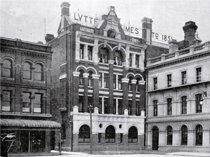
The newspaper was established less than a year after Canterbury was settled by the pioneers.
Dad loved the job until his father found out. Had I known at the time what my grandfather said to Dad I would have taken issue with him. At the time I was still at school and even if I had known I would lose an argument against Grandad. Grandma would have supported “Rueben” It was only years later I found out why she always called me that and it was after her favourite brother.
When Grandad confronted Dad, he said “ No son of mine is going to be a scribbler “ and with that, he placed him with a pommy coach painter at a time when stagecoaches were all but redundant. I have never forgotten the name of the old gentleman who taught Dad the painting trade, Harry Dartnell. Over the years, I have wondered what would have evolved if my Grandad had not intervened.
Dad was a natural wordsmith, I would loved to have been a writer and my son who was working in sales in a Christchurch newspaper became bored and went out at 26 years of age to make an offer for the Ellesmere Guardian, only to be told by the proprietor to come back when he had a few more years on his shoulders.
In parting, my son handed him his business card only to be asked if he knew Bill WHITESIDE. “yes, he is my grandfather “ The owner then said “Your grandfather taught me all I know about newspapers” and that is how my son became a newspaper proprietor. His main paper is one he started from scratch. So you can see that writing was in the blood. However, this is about two earthquakes Napier and Murchison, that Bill experienced.
If you look at a map of both New Zealand and Japan you will notice a geological formation quite similar. They are long and narrow. Both counties are prone to irregular earthquakes and at times of a magnitude that cause structural damage and loss of life. Both are situated in what is known as the Ring of Fire. This is a tectonic belt of volcanoes and earthquakes about 40,000 km (25,000 mi) long and up to about 500 km (310 mi) wide, which surrounds most of the Pacific Ocean.
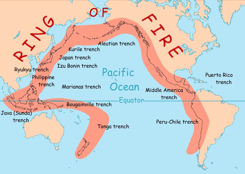
The exact number of volcanoes within the Ring of Fire is not universally agreed but, depending on which regions are included in any particular count, it contains between 750 and 915 active or dormant volcanoes, around two-thirds of the world total. About 90% of the world's earthquakes, including most of its largest, occur within the belt. Japan has 55 volcanoes that are considered active but as we are talking about New Zealand we will leave her to wrestle with the beasts beneath her surface.
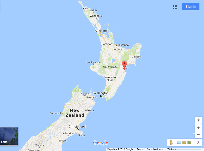
In 1929 Dad was painting at the Napier Hospital, situated on what was known as ‘Hospital Hill’.

Napier Hospital Nurses' Home taken prior to the 1931 Hawke's Bay earthquake.
At 10:47 on the morning of the 3rd of February, an earthquake rocked Napier at a strength that no New Zealanders at that time had experienced. It was violent and lasted for two and a half minutes, with a magnitude of 7.8.
The aftershocks continued relentlessly hampering rescue. By the end of February 600 shocks were recorded. So strong and violent was the noise and ground movement that they were felt as far away as Timaru in the South Island. The carnage, for that is what it was, left a city in complete ruin.
When the shake began people made for the doors to seek a safe harbour in the middle of the street. It was this that added sadly to the death toll that would blowout to become NZ’s greatest natural disaster. To stay inside was to risk being killed by collapsing ceilings, falling walls or possibly fire.

Those who took to the streets were hit by collapsing parapets and walls. There was little they could do except find a way to stay put and hope for the best. A break in the aftershocks saw many make a run for it over brick and mortar-strewn ground only to succumb to falling debris. The earthquake itself set off a ruptured gas pipeline that rapidly saw the flames spread. If there was a definition of hell on earth, this was it.
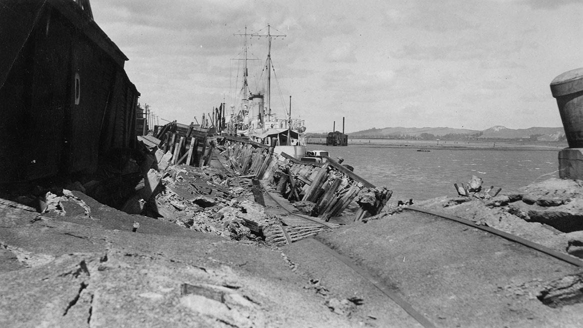
The fire brigade working under extreme difficulty all but extinguished the blaze when the hotel behind broke out and ultimately burnt out the city. The damage was widespread, with power, roads, rail and communication left to the HMS Veronica. Whilst the damage wiped out what had been Napier, the most visual and geographical change was the Port of Napier, where the sea floor was thrust 2.7 metres upwards. Ships at the wharf simply keeled over on their side.
Dad who was painting at the hospital had a perfect view of the harbour and told me about it. In view of the damage and death toll I never knew him to tell me about the city and carnage. He may well have had a reason, but I will never know.
Two years prior to this an earthquake shook violently in the top end of the South Island. Dad’s description of that was more colourful.
On top of a glasshouse painting the steel structure that supported the glass, when the ground began to roll in wave form. He claimed that he dropped his pot through the glass panel that fortunately fell out, dropped to the ground and threw himself flat on the ground. This, the Murchison earthquake was every bit as destructive as what the Napier one was to prove two years later. The centre of the earthquake was around a spot known as White Creek fault in the Buller Gorge. The magnitude of the earthquake in this very heavily hilly, country was such that the rupturing of landscape created no fewer than 38 lakes at the time, but today many have gone. The biggest is Lake Stanley which was caused by a massive landslide that blocked the river and created a lake that is over two klm long. One of the lasting result of the Murchison earthquake is one I was able to show tourist when driving coaches, was the Marcia Falls.

The Murchison earthquake of 1929 created the Maruia Falls by triggering a landslide which diverted the course of the Maruia River westwards, forcing it to cut a new channel over an old river bank. The river eroded gravels below the bank, forming the Maruia Falls. Immediately after the earthquake, the falls were only about a metre high, but after a year, the drop was 5 metres. In the early 2000s it was 10 metres, as shown here
Bruce.


