

Many eons ago, millions in fact, what is now Victoria was a cauldron of volcanic activity, particularly to the north and west. Mt.Macedon, the prominent feature about 50kms north of Melbourne is reputed to have been the largest volcano that ever existed on this planet.
At the time Tasmania was part of the Australian mainland. Along with what is now the Mornington Peninsular a series of granite upthrusts formed a ridge which now features Mt. Eliza, Mt.Martha and Arthur’s Seat. Some millions of years ago Mt. Macedon erupted and sent a gigantic flow of lava to its southeast. This lava flow was restricted to the eastern side of the granite ridge which is about 100 miles from the crater. The lava flowed right across the land and ended at what is now the north-east tip of Tasmania. The rocks in that area have been confirmed as the same rocks that exist in the cliffs at Flinders. This is over 300 miles from the source. You can follow its path from the rich red soil that abounds in the Dandenong Ranges, Berwick, and Red Hill to the east of Arthur’s Seat. It emerges again in the form of the black cliffs of Flinders before disappearing under Bass Strait.
Also at that time, the former Yarra River was a gigantic waterway but I don’t know where it entered the sea.
Some thousands of years later Mt. Macedon erupted again and this time its lava flow went in a south westerly direction and stopped at the You Yangs, the prominent feature that is seen driving to Geelong where there are deposits of pumice. Pumice is a very light rock which is the froth on top of a lava flow and permeated with air bubbles.
Then some thousands of years later there was a tremendous upheaval. The land sunk and formed what is now Bass Strait and Port Philip Bay. The Yarra River entered the sea at the top of the newly formed bay, the former channels that formed a delta of the old Yarra River became isolated deep water channels among a series of mud banks.
This upheaval created a rocky jagged shoreline along the coast from Port Philip Heads to the South Australian border and is now known as The Shipwreck Coast, named after the hundreds of sailing ships that came to grief approaching Port Philip Heads with a lee shore on their port side and being driven by the prevailing south westerly seas coming all the way from Antarctica.
These serious navigational hazards prompted the construction of many lighthouses along the Victorian coast but the entrance to Port Philip was the most hazardous and most complicated challenge to navigation. There are 41 lighthouses standing on the Victorian coast from Gabo Island to Cape Nelson near Portland. 18 of these are within the confines of Port Philip Bay.

The most complex group are those controlling the entrance to Port Philip Bay. Ocean-going ships are not permitted to traverse the entrance unless they have either a pilot on board or the captain has an exemption certificate confirming his ability to navigate through safely. This applies to navy ships as well. See following video on the work of the Port Philip Pilot Service.
Port Phillip Sea Pilots from W&W Productions on Vimeo.
The light complex at Queenscliff works in conjunction with the Point Lonsdale Lighthouse. The Queenscliff complex is located on a prominent feature known as Shortland’s Bluff. It is well within the bay but sits directly opposite the entrance. The entrance, known as The Rip, is about 3 miles wide from point to point but there are reefs protruding from the east or Point Nepean side that jut into the entrance for about 1.5 miles confining the deeper channel to the western side.
The best known is the Corsair Reef that sits just below high water virtually in the middle of the entrance and coming from the eastern, or Point Nepean side.
The Rip is a dangerous piece of water. I have sailed through it several times on an ocean going yacht. I am never relaxed. It is a series of whirlpools and eddies and runs at a fast rate. Slack water is generally understood by sailors to be the changing of the tide and lasts for about half an hour before the tide starts to move again. Slack water at Port Philip Heads is the reverse. It occurs at mid-tide when the water inside the Heads and outside, are level. Due to the narrow entrance with two large bodies of water on either side the sea level in Bass Strait is always higher or lower than the sea level inside in Port Philip Bay. In the numerous undertakings to widen and deepen the Rip divers can work for about half an hour before the current is too strong for them. It is said to run at 28 knots at full flood or full ebb.
The light complex is the most complicated and exacting of any port in the world. It is a series of coloured lights and the lighthouses are on two levels referred to as the High Light and the Low Light each showing a white sector. There are two separate towers in each set. On each side of the High light there are two more steel structured towers which show red lights. These mark the east and west limits of the Fairway channel and any deviation into either sector will find the ship running aground.
When a ship approaches the Rip it has to heave to and take on a pilot from the Port Philip Pilot Service. The pilot then lines up the Point Lonsdale light to port then he lines up the low light with the high light. The Low Light is a white 28 metre stone tower built in 1863 at a cost of 1,865 pounds. It shows white, red and green occulting lights visible for 10 miles. When the two lights are lined up and the ship is sailing in the white sectors it is in mid-channel
The High Light is a black 25 metre stone tower originally built in Scotland and sitting 40 metres above sea level. It was dismantled, the stone blocks numbered and shipped to Port Philip as ballast in a sailing ship, then re-erected where it now stands.
Queenscliff [Black Lighthouse] 01 from In-Flight-Image on Vimeo.
It is now listed by the National Trust and is within the boundary of Fort Queenscliff under the jurisdiction of the Army. It shows a white occulting light every 15 seconds and is visible for 14 miles.
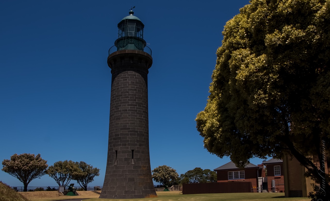
QUEENSCLIFF HIGH LIGHT, BELLARINE PENINSULA
For those not accustomed to nautical terms a flashing light is one which is off and flashes on. An occulting light is one that is on and flashes off. That means that the High Light is on and every 15 seconds goes off then comes on again.
Adjacent to the High Light is a signal station erected during the 1800’s and a collection of lighthouse keepers cottages. Along with all other lighthouses on the Australian coast these towers are no longer manned and are controlled remotely.
There are two channels leading from the Heads to Melbourne, 70 miles away as the crow flies. The west channel is for smaller ships of shallow draft only. The main shipping channel is the South Channel which is the main course of the ancient Yarra River.
The next key light in the complex is the Monash light located on a hill at Portsea 48 Metres above sea level. Built in 1930 and named after John Monash, it is a black and red brick structure showing a white occulting light every 15 seconds. It is the end channel marker for the West Channel and the lesser Coles Channel.
The next and more important light is the South Channel Pile Light. This is the front light of the South Channel. Which runs for another 30 miles up to the Hovell Light which is the rear light of the channel. The light is built in the water on piles sitting 9 metres high and flashing a white light every 1.5 seconds. It has two red, two white and one green sector. Built in 1874 at a cost of 1,725 pounds. Before it was automated it was manned by a staff of three who lived on the light and changed shifts every month. When on duty the light had to be manned by two at all times. Today the living quarter structures are in dilapidated condition and houses thousands of sea birds giving off the most terrible odour.

South Channel Pile Light, Port Phillip, November 2009
Wikimedia Creative Commons photo by Paulp67
When a ship passes through the Heads, the pilot lines up the South Channel Light and does a sharp right turn towards it. When it arrives at the light it can then pick up the red and green channel marker lights which are not lighthouses and are all automated. The channel marker lights are alternately red and green with the red to port and green to starboard when going up channel to Melbourne. Outward bound they are the reverse.
The next complex is the Hovell light and the Eastern Light at McCrae. When a ship passes an imaginary line between the two It then sets a course of due north which takes it in deep water to the Fawkner Beacon, the start of the Port Melbourne Channel. If ships going to Geelong, the main grain loading port of Victoria, they take a due west course to pick up the Corio Channel.
The Hovell Light, named after William Hovell who with Hamilton Hume made the first overland journey from Sydney to Port Philip, is a white round hut built on a concrete base standing on timber piles. Originally built in 1924 it was wrecked in a storm in 1938 and replaced with the present structure in 1939. Standing 7 metres above sea level and visible for 9 miles its white light flashes twice in a group every 8 seconds. I watch it at night from my bedroom window. It marks the north end of a big sandbank called the Hovell Bank
The Eastern Light, also known as The McCrae Lighthouse is the best known structure around the bay. Mounted on land adjacent to the McCrae Yacht Club, it is a silver grey iron structure 34 metres high and beamed an occulting white light every 15 seconds facing wet and north. It has a red sector facing North West and is visible for 13 miles. Along with several similar lights on the Australian coast, it was built in England and shipped here in 1874. It was previously manned and has a keepers’ cottage adjacent to it but is now remotely controlled. Four years ago the South Channel and the Rip were dredged deeper to allow bigger container shops to serve the Port of Melbourne. The channel markers were extended and both the Hovell and Eastern lights were de-commissioned as working lighthouses. The McCrae Lighthouse has been classified by the National Trust and recently underwent a complete restoration. Its navigation lights were blanked out and now face inland as floodlights giving a beautiful scene to the village of McCrae.

Eastern Light, McCrae, September 2019
The next feature on the route to Melbourne is the Fawkner Beacon, named after John Pascoe Fawkner. This marks the start of the Port Melbourne Channel which leads to the port and the entrance to the Yarra River.
Back down at the south end of the bay there are a series of other lights and structures built for navigation and defence. The bottom end of Port Philip Bay is a mass of very shallow water peaking at a low lying mud bank called Mud Island. One can get out of a boat and walk around in shin deep water and it makes for quite hazardous boating let alone danger for big ships.
The well-known feature sitting at the end of the Popes Eye Bank is the Wedge Light. Which has a pile structure built in 1930 with a white light flashing every 3.5 seconds and visible for 9 miles. When aligned with the Monash light it marks the start of the west channel to Geelong. The Popes Eye Bank faces directly through Port Philip Heads. In the days of the Crimean War a Russian invasion was feared and a stone cairn 100 metres in diameter was built on the edge of the bank in the 1870’s.

HMVS Cerberus berthed at Williamstown during the late 1800s.
The tactic was that HMVS Cerberus, a semi-submersible iron clad monitor of the Royal Victorian Navy would enter behind this structure, known as The Annulus, flood her tanks and settle on the bottom with her one heavy gun peeping over the top ready to blow and invader out of the water. Today it is a haven for pleasure craft and a well known item that can be seen by passengers passing on the Sorrento to Queenscliff ferry.
Further along the south channel opposite Rye is a very large stone island which has no lighting at all and built in relatively deep water to the west of the channel. It was also built at the time of the Crimean War and there were to be 7 of them but money became an insurmountable hurdle. The strategy was that if the Russians got past the Pope’s Eye and did not run aground elsewhere they could be blown out of the water by the massive disappearing guns installed at the fort and at Queenscliff.
In the 1800’s Williamstown was the main port to serve Melbourne. The first navigational light in Victoria was erected on the site of the now the Williamstown Lighthouse and Timeball Tower. The present tower was built on 1852 with bluestone blocks quarried on-site by convicts and built by free men. In 1853 a Timeball apparatus was installed. This operated daily at 1.00pm every day until 1926 and enabled ships masters to reset their watches to accurate local time. In1926 the timekeeper died and nobody discovered him for 10 days. It was then realised that the service was not missed so it was never re-started. Wireless communication had rendered it redundant.The 27 metre tower still flashes a red and green light every 7.5 seconds visible for 15 miles.
There are many other lighthouses around Port Philip Bay as depicted in the map but those described above cover the major guides to big ship navigation. The rest are of minor or local consequence only. With the expansion of lighted channel markers many of the older lighthouses have become home to sea birds and seals. You don’t fish near them unless you want a seal to jump into your boat.
There are no longer any manned lighthouses on the Australian coast. The last was in Tasmania, converted to automatic in 1995.
BLOG COMMENTS POWERED BY DISQUS


