

On December 9, 2019, tragedy struck New Zealand as White Island, an active stratovolcano located in the Bay of Plenty, erupted.
The eruption led to the loss of lives, severe injuries, and left an indelible mark on the nation's history.
White Island, also known as Whakaari in Maori, is an active volcano situated about 48 kilometres off the eastern coast of New Zealand's North Island. It is a popular tourist destination, attracting visitors with its otherworldly landscapes and unique geological features.
I spent my teenage years in this region, growing up in the Bay of Plenty on the Volcanic Plateau. My parents had a holiday home at Lake Tarawera, the site of another volcanic eruption in 1886. New Zealand is known as the Shaky Isles for a reason.
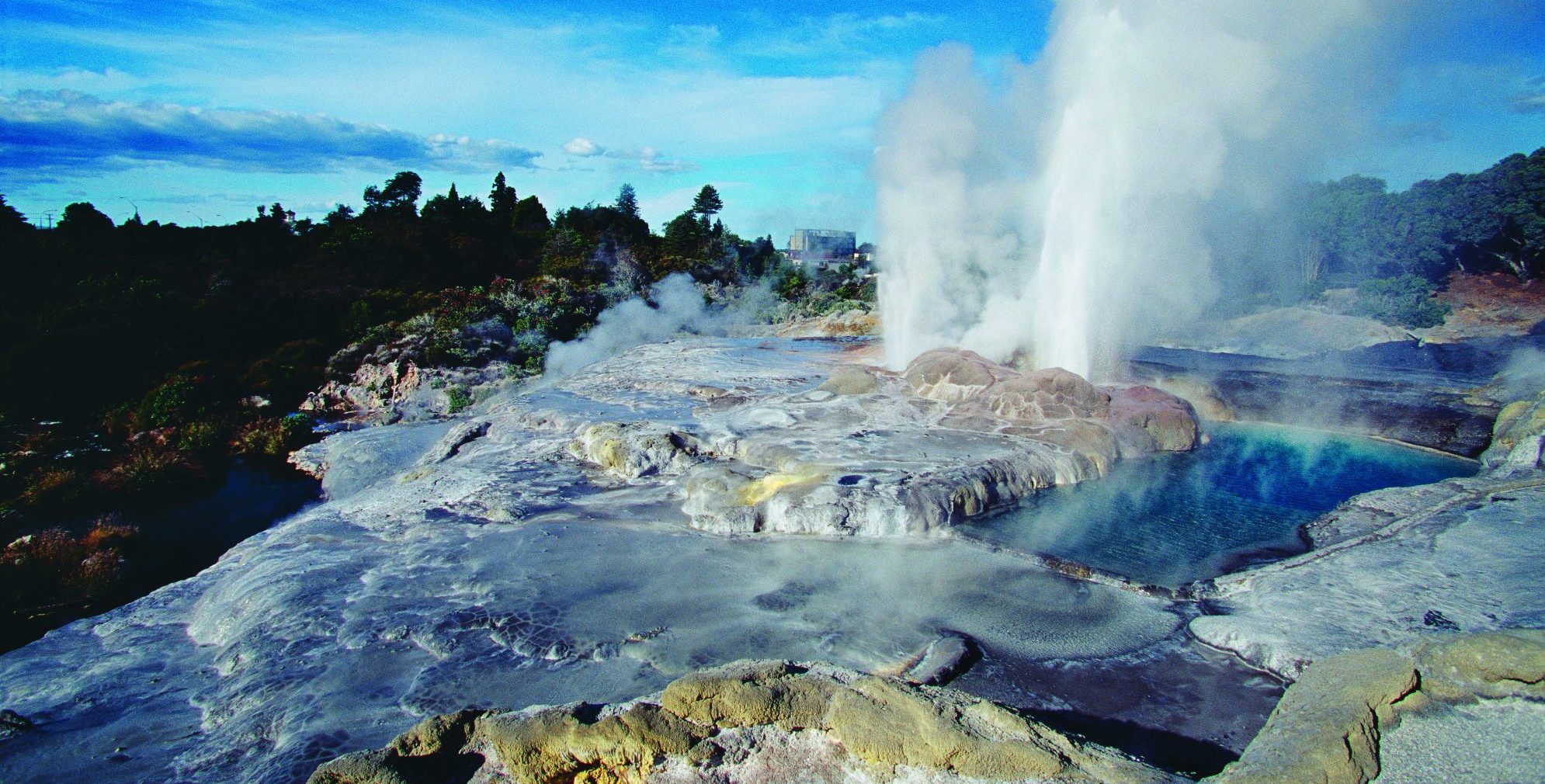
Whakarewarewa Thermal Village
One thing that got me about this particular event, however, was not only the horror of the event, but the fact that so many civilians assisted in the rescue operation. They were incredible heroes.
Dunkirk was about 34 km from Britain. White Island? 48 km.and private boats and choppers did an exemplary job of evacuating survivors. Twenty-two people died, either in the explosion or from injuries sustained, including two whose bodies were never found and were later declared dead. A further 25 people suffered injuries, with the majority needing intensive care for severe burns
New Zealand is located on the Pacific Ring of Fire, a region characterised by high seismic and volcanic activity. The country experiences frequent earthquakes and is situated along the boundary of the Australian and Pacific tectonic plates. The interaction between these plates results in significant geological activity, including earthquakes and volcanic eruptions.
The term "Shaky Isles" reflects the reality that New Zealand is prone to seismic events, and the land itself is shaped by tectonic forces. The country's complex geological setting includes fault lines, subduction zones, and volcanic activity. As a consequence, earthquakes are relatively common, ranging from minor tremors to more significant events that can cause damage to infrastructure and impact communities.
As a child, it was a fairly common event to have a bit of rough and rumble while at school and we would just pop under our desks and wait until it was over before getting up and sitting down and starting the lesson again. It was no big deal really.
We lived in Rotorua, home of boiling mud pools, steam coming out of the drain systems and the smell of sulphur in the air. It was home and perfectly natural to us.

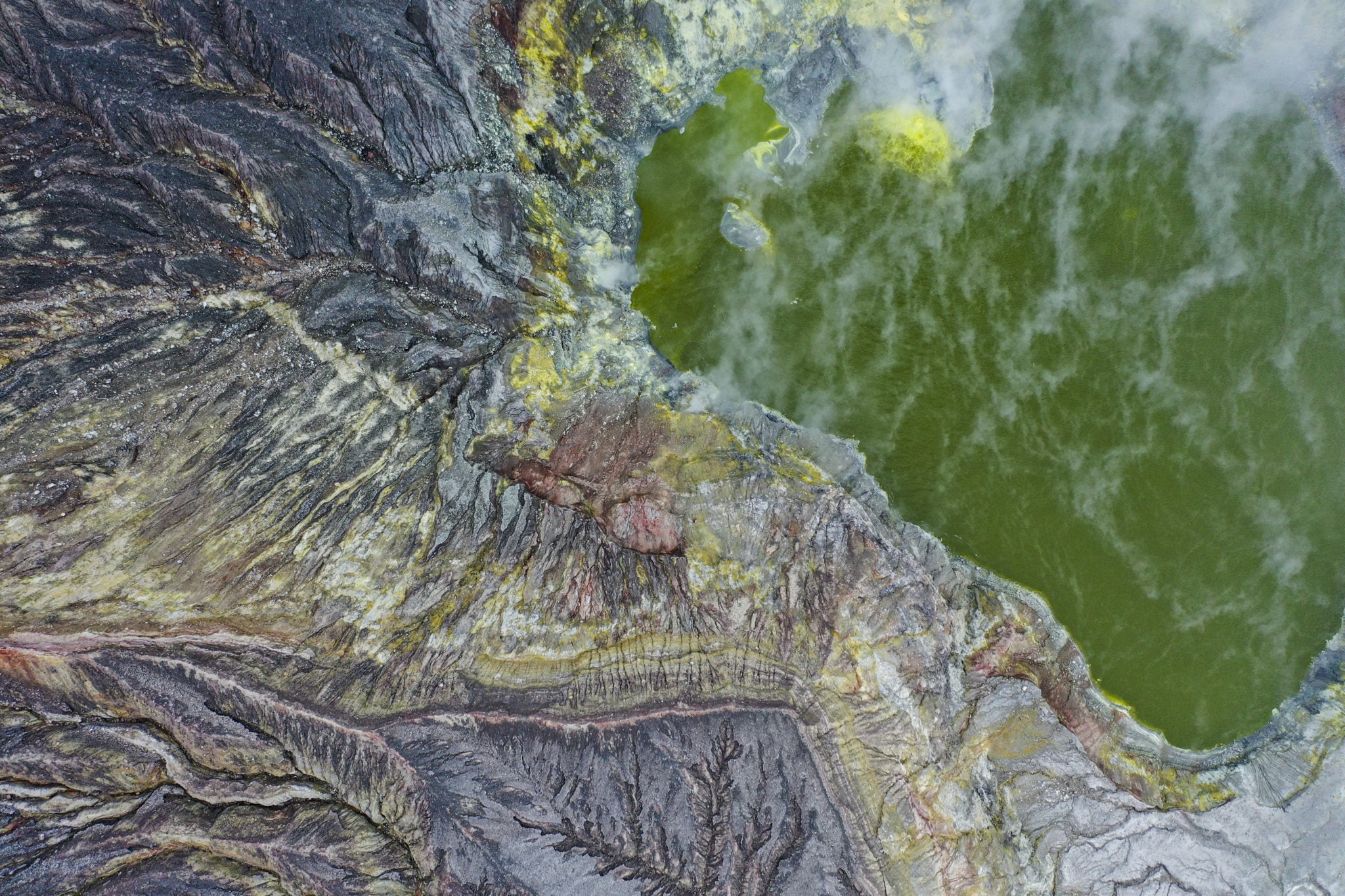
Lake Rotomahana
Mount Tarawera erupted in 1886 and. while it is not part of this article, it is certainly a monumental event in New Zealand history. In short, earthquakes and volcanic eruptions and disruptions are part of a Kiwi's DNA. Who could forget the horrific earthquake in Christchurch in 2011.
I can therefore defend the decision decision to leave a man on White Island, as referred to in yesterday's article. We had become blase about such trifles as volcanic eruptions, earthquakes and the odd inconvenience of a troublesome Mount Doom.
Thank goodness that fishing trip was in the 1970s and not 50 odd years later.
On December 9, 2019, at approximately 2:11 PM local time, White Island explosively erupted. At the time, 47 individuals, including tourists and tour guides, were on the island. The eruption sent plumes of ash and steam into the air, and reports suggested that rocks and debris were thrown across the crater.
White Island is classified as an active stratovolcano, and while it has a history of volcanic activity, the eruption in 2019 caught many by surprise due to its sudden and explosive nature. The island had been showing signs of increased volcanic activity in the weeks leading up to the eruption, with heightened levels of volcanic tremors and the release of sulfur dioxide gas.
The ownership of Whakaari / White Island was one of the first two cases heard by the Native Land Court of New Zealand (now called the Māori Land Court), the other being ownership of nearby Motuhora. ( Whale Island ). Retireti Tapihana (Tapsell) brought the case in 1867, claiming ownership. Retireti was the son of Phillip Tapsell and Hine-i-tūrama Ngātiki. Ownership was awarded jointly to Retireti Tapihana and his sister Katherine Simpkins.
In 1874, the island was sold to the partnership John Wilson and William Kelly by the estate of Retireti Tapihana (Tapsell). Wilson and Kelly subsequently leased it to the Auckland-based partnership of Stewart and Appleby, however after the conditions of the lease were unfulfilled; it was put up for lease again.
The island is privately owned by the Buttle family trust. It was bought by George Raymond Buttle, a stockbroker, in 1936. Buttle later refused to sell it to the government, but agreed in 1952 that it be declared a private scenic reserve. In 2012, the island's title was transferred to the Whakaari Trust, whose shareholders are Peter, Andrew and James Buttle.
Despite the warning signs, the island remained open to tourists on the day of the eruption. The tragic incident prompted questions about the adequacy of risk assessments and safety protocols for tourist activities in volcanic zones.
" We weren't told about the risks so that we could make an informed decision. It was a huge piece of information to be left out. " Hmmm.... sound familiar?
The day before, on 8 December the instruments that measure tremors in nanometres momentarily spiked 30 per cent higher than any tremor during the previous two months. Or perhaps for a moment during a video shot by tourist Allessandro Kauffmann earlier in the afternoon. Kauffmann was part of the group aboard Phoenix, a White Island Tours vessel, and he videoed much of the island tour. At about 1.30pm, he panned along the hot, strangely bright stream flowing from the crater lake. Amid the snap and spit of boiling mineral water, the microphone caught an off-camera aside by a White Island Tours guide: “I’m a little bit worried why it’s going green.”
This is so hard to believe. Our whole tour group were literally standing at the edge of the main crater not 30 minutes before. My thoughts with the families of those currently unaccounted for, the people recovering now, and especially the rescue workers… pic.twitter.com/mn704hobRk
— Michael Schade (@sch) December 9, 2019
Attitudes to Whakaari have long been cavalier. In 1914 miners drained the crater lake to uncover deeper deposits of sulphur. Geologists suspect this affected the stability of the crater cliffs, because in September that same year, a 300m-wide chunk collapsed. As it fell, the rock, weakened by heat and saturated with water, mutated from an avalanche into a highly fluid lahar (a violent type of mud or debris flow), which ran for more than 1km eastward to the sea, burying the 11 miners and destroying the sulphur factory.
A lake of hot acid fills Whakaari’s western sub-crater. It’s 20–25m lower than the main crater floor. The water, which ranges in temperature from 30ºC to 50ºC, is 60 times more acidic than battery acid. (Image credit: Richard Robinson)
It was initially believed that there were about 100 tourists on or near the island when the eruption took place; later, this figure was revised to 47 people who were on the island at the time. Of these people, 38 were passengers on a shore excursion from the cruise ship Ovation of the Seas, which was on a 12-day voyage around New Zealand and had berthed at the Port of Tauranga that morning.
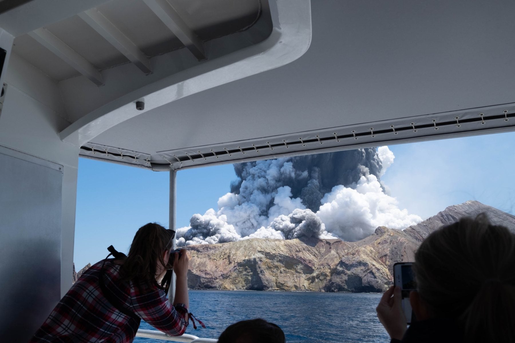
At 2.12pm American tourist Michael Schade photographed the eruptive column surging into the sky from tour boat Phoenix. The last photo he had taken while still on the island was date stamped 1.49pm – 22 minutes before the deadly eruption. (Image credit: Michael Schade)
Some visitors were waiting for vessels to take them off the island at the time of the eruption. Tour operators and these vessels rescued 23 people from the island before it was officially declared unsafe.
My god, White Island volcano in New Zealand erupted today for first time since 2001. My family and I had gotten off it 20 minutes before, were waiting at our boat about to leave when we saw it. Boat ride home tending to people our boat rescued was indescribable. #whiteisland pic.twitter.com/QJwWi12Tvt
— Michael Schade (@sch) December 9, 2019
A passenger on one of the boats stated that his vessel attempted to first outrun the ash cloud before many on the vessel noticed a crowd of people in need of help on the jetty. Those who were brought onto the boat were aided by the original passengers who used water bottles, jackets and other clothing, inhalers, and eye drops.
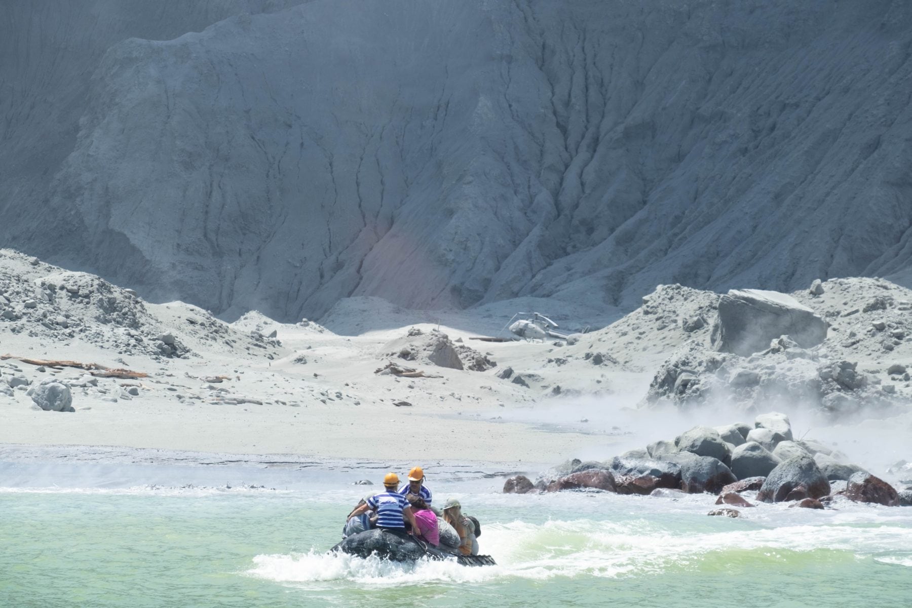
By 2.24pm White Island Tours guides (in blue striped shirts) were rescuing survivors from the landing aboard Phoenix’s inflatables, a scene also photographed by tourist Michael Schade. (Image credit: Michael Schade)
Another passenger told reporters that the boat he was on, which was about 200 metres (220 yd) offshore at the time of the eruption, launched an emergency inflatable and retrieved 23 people before returning to the mainland. Paramedics from the New Zealand Coastguard boarded the boat before it reached the docks to tend the injured.
Noticing the eruption from the mainland shore, three commercial helicopter pilots conducted rescue missions to the island in their helicopters, bringing back twelve survivors. They also saw several bodies in the area, but concentrated on bringing back the survivors. The pilots reportedly attempted to return to the island to collect the bodies they had seen but were stopped by police; however, they were consulted later in order to collect the bodies once the area became more stable.
As the sea-to-shore rescue got underway, an air-to-ground rescue was assembling. The rising plume from Whakaari had served as a shrill alarm for pilots from Whakatane, Rotorua and Taupo. Mark Law, head pilot of Whakatane-based helicopter operators Kahu NZ, saw the eruption as he drove back from Tauranga in his car. He got on the phone, and the Kahu base confirmed that GNS Science’s monitoring cameras on the island had blanked out. Simultaneously, high above the blue expanse of the Bay of Plenty, a helicopter pilot who had lifted off from Whakaari just six minutes earlier called his head pilot, Tim Barrow, at Volcanic Air, and described the scale of the eruption. Barrow then called Law.
Meanwhile, retired helicopter rescue pilot John Funnell was in the air in a small fixed-wing aircraft near Whakatane, keeping up his flying hours. As two Kahu choppers prepared to lift off for Whakaari, with pilots Law, Jason Hill and Tom Storey aboard, Funnell was enlisted as ‘top cover’, a specific role within emergency operations – the top cover is the fixed-winger that circles high above the scene and transmits information received from the team below.
So a small airborne unit was formed, bound together not by official roles or rehearsals, but by the natural meshing of grave concerns and aided by local knowledge of landing pads within the crater.
In December 2022, Netflix released The Volcano: Rescue from Whakaari and used first person accounts along with footage of the eruption and its aftermath, to document the time leading up to, during and after the eruption. I have watched it and can thoroughly recommend it.
A court ruling last month found the owners of Whakaari/White Island volcano guilty of failing to adequately communicate the risks to visitors touring the active volcano by breaching workplace safety laws. The company, Whakaari Management Limited - the holding company of landowners Andrew, James and Peter Buttle - had not met its obligations to visitors to the volcano.
I wonder what courts will say about the vaccinations for Covid? Time, no doubt, will tell. Or, because it has been our governments at fault, will it be just buried under a rather toxic cloud of dust? I fear that there is a volcano brewing in that regard and when it blows, it will be explosive.
Further reading
BLOG COMMENTS POWERED BY DISQUS


